



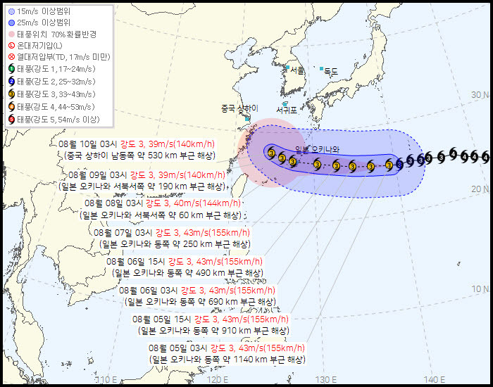
- KMA leans toward "heading to China"… Japan and AI models raise possibility of entering the Yellow Sea
- If heading to China, overlapping easterlies and foehn phenomenon could worsen "extreme heatwaves" up to 39°C in the metropolitan area
- If moving north via the Yellow Sea, the inflow of rain clouds becomes a variable for easing prolonged droughts and heat
- Nationwide daytime highs to hit 38°C on the 5th… Heatwaves to persist through the weekend amid a surge in heat-related illnesses
As the projected path of the 13th Typhoon 'Dolphin' varies among meteorological models from different countries, its final trajectory is expected to determine whether the heatwaves on the Korean Peninsula will be prolonged.
According to the Korea Meteorological Administration (KMA) on the 5th, Typhoon Dolphin was moving westward at a speed of 26 km/h from about 1,140 km east of Okinawa, Japan, as of 3 a.m. that day. It is maintaining its strong intensity with a central pressure of 950 hectopascals (hPa) and a maximum wind speed of 43 meters per second. Dolphin is expected to approach near Okinawa on the 8th with its moving speed sharply dropping to 13 km/h, but its intensity is projected to be maintained for the time being.
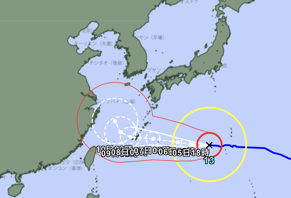
Differences in perspective exist among forecasting agencies regarding the typhoon's track after passing Okinawa. While the KMA predicted it would head toward the sea southeast of Shanghai, China, around the 10th, the Japan Meteorological Agency and some weather AI models have adjusted their paths northward, leaving open the possibility of entering the Yellow Sea.
This difference in paths could lead to extreme and contrasting weather outcomes in South Korea. If Dolphin heads toward China as the KMA forecasts, strong easterly winds will flow into the Korean Peninsula due to the typhoon's counterclockwise circulation. A foehn phenomenon will occur as these winds cross mountain ranges and become hot and dry, exacerbating extreme heatwaves centered around western regions such as Seoul and Gyeonggi Province. On the other hand, if the typhoon moves north into the Yellow Sea, the influence of its outer rain clouds could simultaneously alleviate the prolonged drought and heatwaves.
Currently, the Korean Peninsula is suffering from severe heatwaves even before the indirect effects of the typhoon. Nationwide daytime highs on the 5th were recorded between 30°C and 38°C, and some parts of the metropolitan area are forecast to soar to 39°C. Heavy heatwave warnings have already been issued for major areas nationwide including the metropolitan area, and with temperatures expected to hover around 37°C through the weekend, special caution and preparation against heat-related illnesses are required.