



- Expansion of North Pacific High… nationwide heat advisories expanded and tropical nights persist
- Up to 60mm of localized showers concentrated inland due to intensifying atmospheric instability
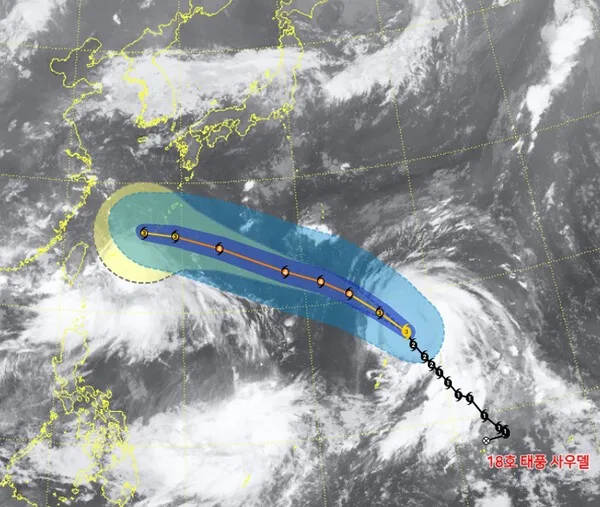
- 18th Typhoon 'Soudelor' path to become clearer after reaching Okinawa next week
Amid a scorching heatwave with daytime felt temperatures soaring to around 33 degrees Celsius, surprise showers of up to 60mm are expected to hit various inland areas. In addition, the 18th Typhoon 'Soudelor', developed over the waters north of Guam, is moving northward, emerging as a core variable for next week's weather conditions on the Korean Peninsula.
The Korea Meteorological Administration announced that as the North Pacific High expands its influence toward the Korean Peninsula, heat advisories previously limited to the southern and Chungcheong regions over the weekend will expand nationwide inland. Tropical nights are expected to continue mainly in urban and coastal areas as temperatures fail to drop even at night.
Surprise precipitation is also continuing due to atmospheric instability caused by surface heating. Following heavy downpours exceeding 30mm per hour in Seongnam, Gyeonggi Province, and Wonju, Gangwon Province during the early morning hours—which prompted heavy rain advisories—shower clouds bringing up to 60mm are expected to develop across all inland areas in the afternoon. Because rain will be concentrated in specific areas over a short period, preparations against low-lying area flooding and safety accidents are urgent.
The variable is the typhoon moving across the distant southern seas. The 18th Typhoon 'Soudelor' is scheduled to pass north of Guam this weekend and reach the waters near Okinawa, Japan, by the middle of next week. While current numerical forecast models suggest the possibility of a landfall on the Chinese mainland, the possibility of it turning its direction toward the Korean Peninsula along the edge of the North Pacific High cannot be ruled out. The Korea Meteorological Administration is closely monitoring the forecasts, expecting the detailed path of the typhoon to be determined after the middle of next week.